
Applications and Investigations in Earth Science (9th Edition)
9th Edition
ISBN: 9780134746241
Author: Edward J. Tarbuck, Frederick K. Lutgens, Dennis G. Tasa
Publisher: PEARSON
expand_more
expand_more
format_list_bulleted
Textbook Question
Chapter 8.6, Problem 1A
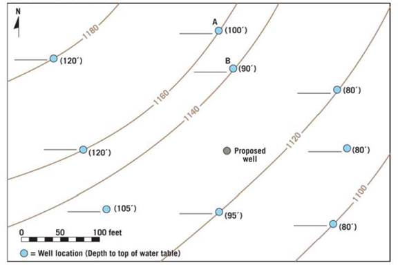
Calculate the elevation of the water table at each well location and write the approximate elevation on the line next to each well. Next, use a colored pencil to draw smooth 10-foot contours that show the shape of the water table. (Start with the 1160-foot contour.) Use a pencil of a different color to draw arrows on the map to indicate the direction of the slope of the water table.
| a. | Toward which direction (downward) does the water table slope? |
| b. | Referring to the site of the proposed water well, at approximately what depth below the surface should the proposed well intersect the water table? |
Expert Solution & Answer

Learn your wayIncludes step-by-step video

schedule01:48
Chapter 8 Solutions
Applications and Investigations in Earth Science (9th Edition)
Ch. 8.1 - Sketch, label, and discuss the hydrologic cycle....Ch. 8.1 - Sketch, label, and discuss the hydrologic cycle....Ch. 8.1 - Sketch, label, and discuss the hydrologic cycle....Ch. 8.1 - Sketch, label, and discuss the hydrologic cycle....Ch. 8.1 - Sketch, label, and discuss the hydrologic cycle....Ch. 8.1 - Label the drawing in Figure 8.2 with the letters...Ch. 8.2 - Of the three materials you tested coarse sand,...Ch. 8.2 - Prob. 2ACh. 8.2 - Prob. 3ACh. 8.2 - Prob. 4A
Ch. 8.3 - Does urbanization increase or decrease the peak...Ch. 8.3 - What is the effect of urbanization on lag time the...Ch. 8.3 - Does total runoff occur over a longer or shorter...Ch. 8.3 - Based on what you have learned from the...Ch. 8.4A - Compare the stereogram in Figure 8.7 to the map in...Ch. 8.4A - Is the terrain in section 14, located on the west...Ch. 8.4A - Label the areas that topographically resemble...Ch. 8.4A - Describe the topography in the lower half of...Ch. 8.4A - Section 17 contains a portion of the valley...Ch. 8.4A - Which of the following best describes the shape of...Ch. 8.4A - Calculate the gradient, or slope, of this portion...Ch. 8.4A - Approximately how many feet is the Missouri River...Ch. 8.4A - What are the features in the river labeled with...Ch. 8.4A - Based on your answer to Question 9, are the...Ch. 8.4A - Over time, as tributaries erode and lengthen their...Ch. 8.4B - Draw an arrow on the map to indicate the direction...Ch. 8.4B - Use the BM elevations from Question 1 to calculate...Ch. 8.4B - Approximately how many feet is the Genesee River...Ch. 8.4B - The path of the Genesee River can best be...Ch. 8.4B - Which phrase most accurately describes most of the...Ch. 8.4B - Use the fractional scales on the Angelica...Ch. 8.4C - Approximately what percentage of the map area is...Ch. 8.4C - Prob. 2ACh. 8.4C - Prob. 3ACh. 8.4C - Prob. 4ACh. 8.4C - Prob. 5ACh. 8.4C - Write a statement that compares the width of the...Ch. 8.4C - Is the Red River actively downcutting its channel...Ch. 8.4C - On which of the three maps is the gradient of the...Ch. 8.4C - Choosing from Figure 8.6, Figure 8.8, or Figure...Ch. 8.5 - Label the zone of saturation, the unsaturated...Ch. 8.5 - Describe the shape of the water table in...Ch. 8.5 - Whenever a substantial amount of water is...Ch. 8.5 - Use a pencil to shade the area between the dashed...Ch. 8.5 - How does the drop in the water table during a...Ch. 8.6 - Calculate the elevation of the water table at each...Ch. 8.6 - Assume that a dye was put into well A on May 10,...Ch. 8.7 - What is the general relationship between ground...Ch. 8.7 - What was the total ground subsidence, and what was...Ch. 8.7 - During the period shown on the graph, on average,...Ch. 8.7 - Was the ground subsidence that occurred between...Ch. 8.7 - Notice that minimal subsidence occurred from 1935...Ch. 8.8 - Locate three sinkholes depressions on the map and...Ch. 8.8 - Notice that several sinkholes have water in them....Ch. 8.8 - Describe what is happening to Gardner Creek in the...Ch. 8 - Write a statement or two describing the movement...Ch. 8 - Assume that you need to determine the rate at...Ch. 8 - Write a brief paragraph summarizing the results of...Ch. 8 - The diagrams in Figure 8.20 show lag time between...Ch. 8 - On Figure 8.21, identify and label as many...Ch. 8 - Name and describe two features you would expect to...Ch. 8 - On Figure 8.22, identify and label as many...Ch. 8 - Assume that you have decided to drill a water...Ch. 8 - Name and describe two features you would expect to...
Additional Science Textbook Solutions
Find more solutions based on key concepts
Why does your soft drink can “sweat” more in the summer than in the winter?
Exercises for Weather & Climate (9th Edition)
a. Draw two Lewis structures for C2H6O. b. Draw three Lewis structures for C3H8O. (Hint: The two Lewis structur...
Essential Organic Chemistry (3rd Edition)
For Practice 1.1
Is each change physical or chemical? Which kind of property (chemical or physical) is demonst...
Principles of Chemistry: A Molecular Approach (3rd Edition)
3. Which of the following is a major functional characteristic of all organisms? (a) movement, (b) growth (c) m...
Human Anatomy & Physiology (Marieb, Human Anatomy & Physiology) Standalone Book
For a solid, we also define the linear thermal expansion coefficient, a, as the fractional increase in length p...
An Introduction to Thermal Physics
Knowledge Booster

Recommended textbooks for you
 Applications and Investigations in Earth Science ...Earth ScienceISBN:9780134746241Author:Edward J. Tarbuck, Frederick K. Lutgens, Dennis G. TasaPublisher:PEARSON
 Exercises for Weather & Climate (9th Edition)Earth ScienceISBN:9780134041360Author:Greg CarbonePublisher:PEARSON
 Environmental ScienceEarth ScienceISBN:9781260153125Author:William P Cunningham Prof., Mary Ann Cunningham ProfessorPublisher:McGraw-Hill Education
 Earth Science (15th Edition)Earth ScienceISBN:9780134543536Author:Edward J. Tarbuck, Frederick K. Lutgens, Dennis G. TasaPublisher:PEARSON
 Environmental Science (MindTap Course List)Earth ScienceISBN:9781337569613Author:G. Tyler Miller, Scott SpoolmanPublisher:Cengage Learning
 Physical GeologyEarth ScienceISBN:9781259916823Author:Plummer, Charles C., CARLSON, Diane H., Hammersley, LisaPublisher:Mcgraw-hill Education,
Applications and Investigations in Earth Science ...
Earth Science
ISBN:9780134746241
Author:Edward J. Tarbuck, Frederick K. Lutgens, Dennis G. Tasa
Publisher:PEARSON
Exercises for Weather & Climate (9th Edition)
Earth Science
ISBN:9780134041360
Author:Greg Carbone
Publisher:PEARSON
Environmental Science
Earth Science
ISBN:9781260153125
Author:William P Cunningham Prof., Mary Ann Cunningham Professor
Publisher:McGraw-Hill Education
Earth Science (15th Edition)
Earth Science
ISBN:9780134543536
Author:Edward J. Tarbuck, Frederick K. Lutgens, Dennis G. Tasa
Publisher:PEARSON
Environmental Science (MindTap Course List)
Earth Science
ISBN:9781337569613
Author:G. Tyler Miller, Scott Spoolman
Publisher:Cengage Learning
Physical Geology
Earth Science
ISBN:9781259916823
Author:Plummer, Charles C., CARLSON, Diane H., Hammersley, Lisa
Publisher:Mcgraw-hill Education,